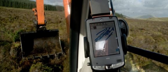
A conventional Ordnance Survey map or even an aerial photograph of an area of land only shows a limited fraction of the information that is required to enable large scale projects to be planned effectively. Dinsdale Moorland Services (DMS) offers a fully integrated GIS mapping package, from collection of raw data and analysis, to production of finished maps. Custom maps can be created to show specific items or a variety of data can be grouped together depending upon the individual client’s requirements.
For remote environments DMS is well equipped with GPS survey vehicles and the necessary on-board computer equipment needed to build a complete picture of the ground including grips, vegetation type, hazards, bogs, holes, bare peat etc.
The ability to edit maps or build upon base maps greatly increases their usability and is particularly helpful when undertaking ground treatment plans over a number of years as locations can be accurately pinpointed and changes on the ground compared. DMS uses Ordnance Survey backing maps and this allows the overlayed information to be easily read and analysed in the field, as well as providing a permanent record of the work undertaken.
In recent years DMS has developed its use of GIS and GPS as vital elements in facilitating safe and efficient moorland contracting. Prior to work on open moorland commencing, a full GPS survey is completed and all machines working in such areas are equipped with GPS equipment so that they can work to a task plan and record progress. Moreover, from a safety perspective, contractors always know their exact position. With fast data collection and handling DMS regularly maps its works as a matter of course. This record of works can then be used to develop future management plans.


